
Location Overview
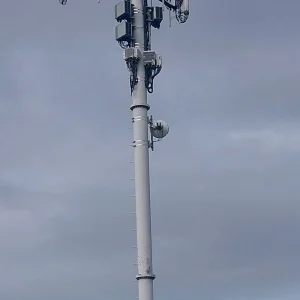
The Spark Masterton Town location is 19m high, has 8 licences associated, and is capable* of 3G UMTS, 4G LTE and 5G.
Location has been manually adjusted based on user feedback.
GIS Geek | LINZ | GMaps | Street View
Login required to upload photos or suggest corrections.
Closest Towers
| Provider | Location Name | Distance | Bearing |
|---|---|---|---|
| Spark | Masterton Exchange | 1.71km | 102.96 |
| OneNZ | Masterton | 1.31km | 61 |
| 2Degrees | Masterton Straights | 1.52km | 140.38 |
| RCG | RWLTWH - Te Whiti | 9.78km | 166.89 |
User Photos
Licence Details
Close Cell IDs Spark MMC: 530 MNC: 5
| Radio | Area | Cell | Distance from tower | Bearing from tower | Samples |
|---|---|---|---|---|---|
| UMTS | 3502 | 15168031 | 53m | 188.91 | 62 |
| LTE | 38141 | 15168031 | 74m | 254.64 | 1 |
| LTE | 38141 | 13307679 | 257m | 233.98 | 1 |
| LTE | 38141 | 13307681 | 379m | 235.64 | 6 |
| LTE | 38141 | 443251 | 780m | 116.84 | 1 |
| LTE | 38141 | 443271 | 780m | 116.84 | 1 |
| UMTS | 38398 | 2535512 | 962m | 33.47 | 26 |
| UMTS | 33202 | 2217830 | 1.12km | 171.69 | 9 |
| UMTS | 48393 | 2537744 | 1.23km | 137.22 | 1 |
| LTE | 38141 | 13307680 | 1.32km | 154.49 | 2 |
| UMTS | 38398 | 2535513 | 1.24km | 137.56 | 1 |
| UMTS | 48393 | 2537741 | 1.24km | 137.42 | 1 |
| UMTS | 48393 | 2537747 | 1.25km | 136.11 | 1 |
| UMTS | 33202 | 2217834 | 1.18km | 235.81 | 3 |
| UMTS | 33202 | 2217831 | 1.18km | 235.81 | 2 |
| LTE | 38141 | 443001 | 1.39km | 163.46 | 2 |