Licence Overview
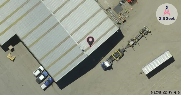
The link registered to Ultimate Mobile Limited is a X band link at 10.915GHz. It transmits from 37 Line Road, Methven (Uml), and is received at Mt Hutt (Uml), a distance of 16.91km.
TX: GIS Geek | LINZ | GMaps | Street View
RX: GIS Geek | LINZ | GMaps | Street View
Login required to upload photos or suggest corrections.
TX Location Client Stats
| Client | Links |
|---|---|
| Ultimate Mobile Limited | 2 |
Licence and Location Details
| TX: 37 Line Road, Methven (Uml) | |
|---|---|
| Antenna | RFS - SCX3-W100A |
| Antenna Type | 11 GHZ 0.9 M DUAL POL |
| Equipment | Siae - ALFOPLUS |
| RX: Mt Hutt (Uml) | |
|---|---|
| Antenna | RFS - SCX3-W100A |
| Antenna Type | 11 GHZ 0.9 M DUAL POL |
| Equipment | Siae - ALFOPLUS |
Associated Licence
| #1: Mt Hutt (Uml) | |
|---|---|
| Frequency | 11.445GHz |
| Frequency Range | 11.405GHz - 11.485GHz |
| Channel Width | 80MHz |
| Channel Code | 11G3W# |
| Power dBW(eirp) | 33 |
| Emission | 80M0D7WWX |
| Licence Type | Fixed >=1 GHz (Bi-directional) |
| Commenced | - |
| Licence Last Updated | - |
| RSM Licence ID | 235200 |
| RSM Licence # | 293757 |
Additional Links From TX Location
Additional Links From RX Location
| Client | TX Location | Band | Frequency | RX Location |
|---|---|---|---|---|
| Connectivity Infrastructure Services Limited | Mt Hutt (Uml) | Ku | 13.157GHz | Rakaia (Rctrak) |
| Connectivity Infrastructure Services Limited | Rakaia (Rctrak) | Ku | 12.891GHz | Mt Hutt (Uml) |
| Ultimate Mobile Limited | Methven (Uml) | X | 10.915GHz | Mt Hutt (Uml) |
| Ultimate Mobile Limited | Mt Alford (Ashley) | Ku | 12.835GHz | Mt Hutt (Uml) |
| Ultimate Mobile Limited | Mt Hutt (Uml) | X | 11.445GHz | Methven (Uml) |
| Ultimate Mobile Limited | Mt Hutt (Uml) | Ku | 13.101GHz | Mt Alford (Ashley) |