Map Enhancements & Advanced Search Features
3D Views & Address Search
Explore terrain and coverage in 3D, and pinpoint services at specific addresses.
Historical Data Analysis
Filter licence data by date to track infrastructure evolution and analyse deployment trends.
Cell Tower Search
Locate specific cell towers by name for targeted coverage and service analysis.
PTP & LMR Search
Search point-to-point links and land mobile radio systems by licensee and tower name.
Fixed Line Search
Quickly find fixed line infrastructure like cabinets by site name.
3D Views & Address Search
This functionality is currently available without subscribing, but will become subscriber only eventually.
Unrestricted Exploration
Enjoy unlimited object interaction without rate limiting. Click and explore as many towers, links, and infrastructure elements as you need without restrictions.
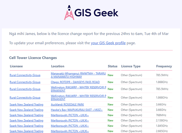
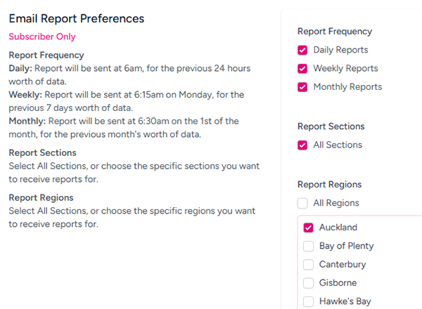
Email Change Reports
Stay informed with customisable email alerts about licence changes. Choose your preferred frequency—daily, weekly, or monthly—and focus on specific regions that matter to you. Never miss important infrastructure updates in your areas of interest.

All standard subscriber benefits for your entire organisation, plus:
Data Export Capabilities
Download complete datasets in GeoJSON, CSV or GPX formats, updated nightly with the latest information.
Seamlessly integrate with your GIS software, custom applications, or analysis tools to enhance your workflow and decision-making process.
(You must be logged in to request example data)
{
    "type": "FeatureCollection",
    "features": [
        {
            "type": "Feature",
            "properties": {
                "provider": "OneNZ",
                "location_name": "DESERT ROAD NORTH",
                "bands": "700, 900",
                "services": "4G LTE, 2G GSM, 3G UMTS",
                "transmit_location_details": {
                    "locationId": 23950,
                    "LocationType": "Point",
                    "address": {
                        "place_name": "Tunnel Ventilation Shaft",
                        "house_number": null,
                        "road": "Kaimanawa Road",
                        "suburb": null,
                        "city_district": null,
                        "city": null,
                        "town": null,
                        "county": "Taupō District",
                        "state": "Waikato",
                        "postcode": null
                    }
                },
                "receive_location_details": {
                    "locationId": 23964,
                    "locationName": "DESERT ROAD NORTH RC AREA",
                    "LocationType": "Multiple Points",
                    "gridReference": [
                        {
                            "GeoRefType": "LAT_LONG_NZGD2000_D2000",
                            "Latitude": -39.4327336,
                            "Longitude": 175.4963308
                        }
                    ]
                },
                "licence_details": [
                    {
                        "licence_id": 213121,
                        "licence_number": 274778,
                        "frequency": "785.50",
                        "last_updated": "2025-03-14",
                        "commencement_date": "2020-03-12",
                        "expiry_date": "2031-11-28",
                        "spectrumRecords": [
                            {
                                "spectrumId": 352907,
                                "spectrumLow": 778,
                                "spectrumHigh": 793,
                                "spectrumStatus": "CURRENT",
                                "serviceType": "Spectrum Private",
                                "polarisation": "M",
                                "remarks": null,
                                "startDate": "2020-03-12",
                                "endDate": "2031-11-28"
                            }
                        ]
                    },
                    {
                        "licence_id": 113458,
                        "licence_number": 208861,
                        "frequency": "952.00",
                        "last_updated": "2024-11-06",
                        "commencement_date": "2016-09-06",
                        "expiry_date": "2031-11-28",
                        "spectrumRecords": [
                            {
                                "spectrumId": 304304,
                                "spectrumLow": 944.8,
                                "spectrumHigh": 960,
                                "spectrumStatus": "CURRENT",
                                "serviceType": "Spectrum Private",
                                "polarisation": "M",
                                "remarks": null,
                                "startDate": "2016-09-06",
                                "endDate": "2031-11-28"
                            }
                        ]
                    }
                ],
                "nearby_cell_ids": [
                    {
                        "radio": "UMTS",
                        "area": 1604,
                        "cell": 26401718,
                        "unit": 416,
                        "samples": 13,
                        "range": 2091,
                        "created_at": "2016-03-25",
                        "updated_at": "2024-03-29",
                        "calc_distance": "5662",
                        "calc_azimuth": "267.9"
                    },
                    {
                        "radio": "UMTS",
                        "area": 1706,
                        "cell": 62381573,
                        "unit": 228,
                        "samples": 32,
                        "range": 25061,
                        "created_at": "2017-01-29",
                        "updated_at": "2025-03-19",
                        "calc_distance": "8221",
                        "calc_azimuth": "343.1"
                    },
                    {
                        "radio": "LTE",
                        "area": 43072,
                        "cell": 278530,
                        "unit": 0,
                        "samples": 17,
                        "range": 17817,
                        "created_at": "2016-03-26",
                        "updated_at": "2024-03-29",
                        "calc_distance": "7489",
                        "calc_azimuth": "254.3"
                    },
                    {
                        "radio": "UMTS",
                        "area": 1604,
                        "cell": 26401560,
                        "unit": 485,
                        "samples": 72,
                        "range": 4912,
                        "created_at": "2016-03-25",
                        "updated_at": "2024-03-29",
                        "calc_distance": "10552",
                        "calc_azimuth": "236.2"
                    },
                ]
            },
            "geometry": {
                "type": "Point",
                "coordinates": [
                    175.8335262,
                    -39.1544512,
                    840
                ]
            }
        }
    ]
}
Discounts may be available for registered non-profits and government departments, please contact us to discuss.